 | |
To contact mi, click here This is an independent site |
|
| |
|
The light Breckland soil, so easy to clear and to plough, has attracted settlers since prehistoric times, especially when it is found next to a river as at West Stow. One of the earliest settlement sites in Britain was discovered just a few miles to the west, and this part of the Lark Valley has the greatest concentration of prehistoric settlements in East Anglia. All our information on the first settlers comes from archaeology. The excavations of the early Anglo-Saxon settlement at West Stow were carried out between 1965 and 1972, but an Anglo-Saxon cemetery had been investigated on West Stow heath in 1865. We know that Mesolithic hunters camped on the low hill and made tools here. Neolithic people cleared the woodland for their fields and so began to form the Breckland heaths. They buried their dead in a burial mound within the present Park boundary. Black flint from the mine at Grimes Graves came down the Icknield Way with traders, and this route was still in use in the Bronze Age. 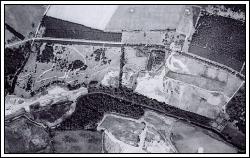 Above: view from the air, 1976, 3 years before the Park opened. From left to right: gravel is being taken to form the lake; the motorbike scrambling track is visible on the heath; three reconstructions have been built on the hill, rubbish is being dumped on the site of the old sewage beds; the car park is taking shape (Made by the Director General of the Ordnance Survey) Iron Age technology and climatic changes combined to advance the rate of woodland clearance for farming in the area. Small Iron Age farms can be found all along the Lark Valley and one was excavated at West Stow, revealing circular huts and ditched enclosures. This area was the home of the Iceni tribe, famous for Queen Boudicca who fought against the Romans. 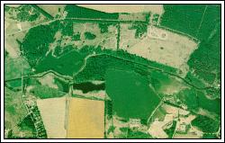 Above: View from the air 1991, 15 years later. From left to right: lake with islands well established; more trees are growing on the heath: six reconstructions on the hill; the Visitor Centre and car park are complete (Made by ADAS Aerial Photography Unit) Please note: as the original purpose of this photograph was to show up crop details the colours may seem unusual. The Roman settlement pattern was rather different, with much larger settlements like the rural market centres at Icklingham and Mildenhall. At West Stow there were pottery-kilns making wares for the region. The Anglo-Saxon settlement discovered here dates from soon after the end of the Roman period, around AD 420. These farmers lived in three or four family groups of houses, each with its hall as a community building. They stayed here up to the time when their famous King Raedwald was buried in his ship with much of his treasure at Sutton Hoo, about AD 625. Some time later the village site on the hill in the present Park was gradually abandoned in favour of a new settlement, further east. at the site of the modern West Stow village. In medieval times there was some farming on the hill. Around AD 1300 major storms resulted in the loose sand of the Breckland being blown over the hill site, covering it with a protective blanket of sand which helped preserve it for archaeologists, Since that time we do not have as much information on the West Stow site; it seems that the heaths were over-grazed and became increasingly unstable. The shifting sands became a prominent feature, destroying any crops in their way and turning much of the area into a desert-like country inhabited mainly by rabbits and sheep. Eventually the Breckland was taken over by huge country estates, where Scots pine windbreaks were planted to try to stop the sand blows. The Culford estate owned the area of the present Park in the early 1800s and sold it to the local council in 1886 for use as a sewage farm for Bury St Edmunds. A pump house, for circulating sewage around the lagoons, was built near the river. This enabled coal-carrying barges to supply the engines, since the River Lark had been made navigable almost as far as Bury St Edmunds. The sewage farm took up the eastern half of the site, until it was eventually replaced by a modern treatment works in 1953. The empty site was used as a rubbish dump for Bury St Edmunds during the 1960s and early '70s, when visitors to the excavations could follow rubbish freighters there. Gravel was extracted from the west of the site and televised motorcycle scrambling took place on the central heath. In 1979 West Stow Country Park was opened. The rubbish tip had been filled in and landscaped, the gravel pit had been turned into a lake and scrambling had stopped. The project was financed by the Borough Council and the Countryside Commission. The Anglo-Saxon reconstructions had been started by the West Stow Anglo-Saxon Village Trust, set up after the excavations closed in 1972. In 1988 a visitor centre was opened to help present the story of this man-made landscape to the general.public. | |